Turtles

by Dana Little, 6/25/13

            Living on the pond’s edge, we occupy prime turtle habitat.  Both the large snapping turtle, up to 20 inches long and 60 pounds, and the smaller, more colorful painted turtle thrive in Taylor Pond.  At our house, every June, a female snapper emerges from the mud on the bottom of the pond, and appears on our lawn or driveway. She’s searching for a nesting site.  Over several hours, she digs up spot after spot in the soft mulch of our gardens, before settling on the right one.  There, she lays and buries 20-30 white eggs, about one inch in diameter.  She returns to the water and often, within 24 hours, we find the location of her raided nest by the broken egg shells strewn about by a marauding fox, mink, raccoon, or skunk.

Female snapping turtle seeking a nesting site.

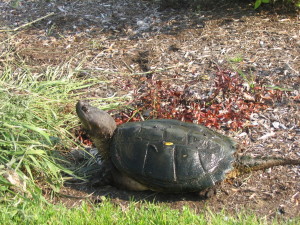
Mother Snapping Turtle searching for a nesting site.

Any remaining eggs will hatch in the fall. The sex of these little survivors is determined by the temperature of their environment.  Females thrive at the extremes, low or high; males, at intermediate temperatures.  Because the temperature in a nest varies with depth usually a blend of males and females occur. The young hatch within 24 hours of each other and emerge en mass, overwhelming predators with their numbers to enhance their chance of survival.  They may climb to the surface immediately or wait until spring to appear.

Snappers, on average, live 30 years, although they can live much longer in captivity.  Aquatic plants compose about a third of their diet.  They often wait hidden in the mud on the bottom of the pond or suspended in the water where they will ambush fish, small birds, frogs and snakes.  Do snappers bite people?  On land their slow speed makes them vulnerable so they will snap if you get too close.  Swimming in the Pond, I’ve met snappers on many occasions. They simply turn and swim away when they spot me.  I am told snappers make good soup.  Unfortunately, they may harbor high levels of toxins.  I prefer to watch rather than eat this creature that’s been around since the dinosaurs ruled.
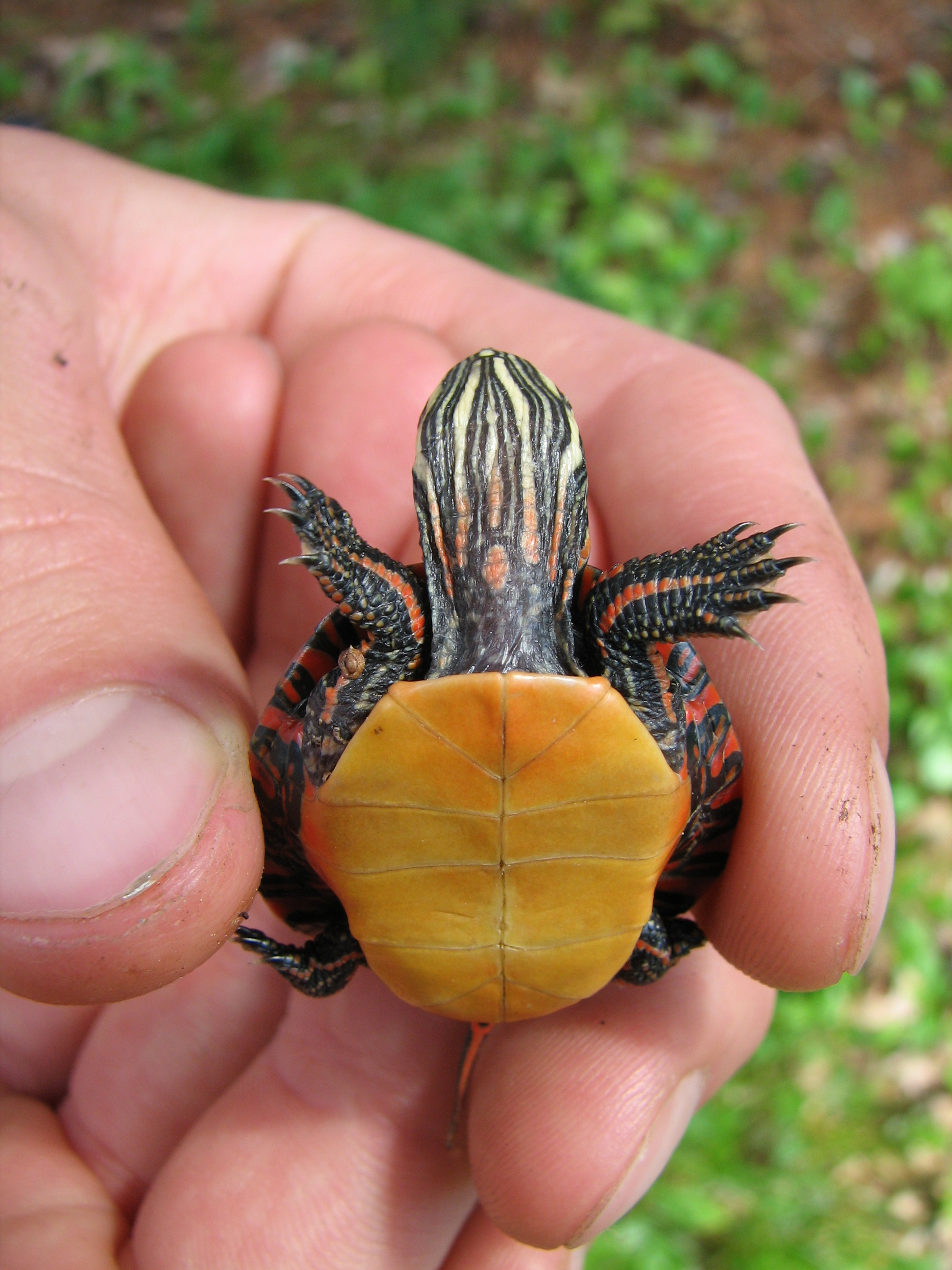
Painted Turtle hatchling

Baby Painted Turtle

Painted Turtles get their name from the bright red, orange and yellow markings on their dark underside shells.  They prefer warm, shallow water where underwater plants are plentiful.  They love to bask in the warm sun. When space is limited, up to four turtles will pile on top of each another.  During the summer they chase small creatures such as insect larvae, baby fish and tadpoles.  They also consume cattails, pondweeds and long strings of algae.  Although they can occasionally be spotted swimming beneath clear ice, in the winter they usually bury themselves in the mud to wait for spring.  Female painteds prefer to lay about 20 eggs in sandy soil in the sun. Painted turtles have been known to live for 13 years but probably live much longer.

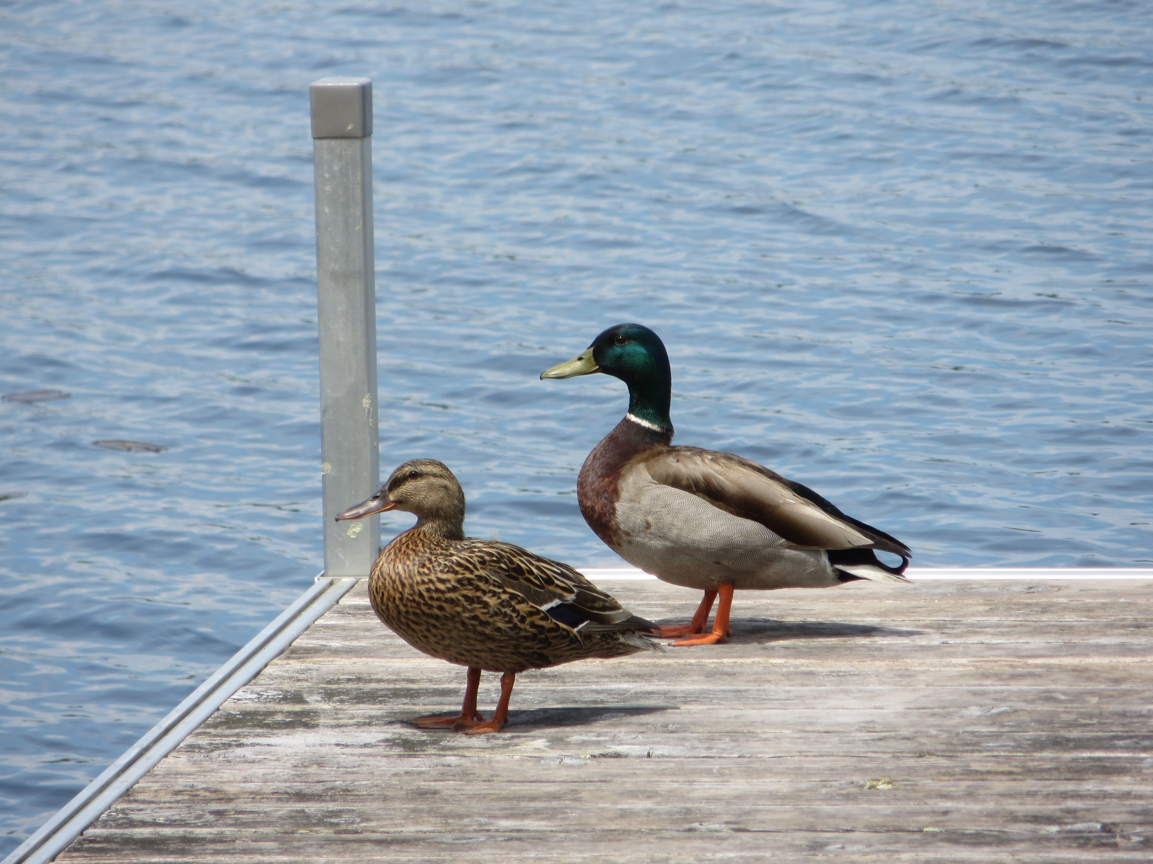
When out in a boat, check that floating piece of log again; it may be a snapper’s head. Scan logs at the water’s edge for basking painted turtles.  If you want to see the snapper or the painted turtle in the water, put on a mask and snorkel, and float quietly in the shallows.
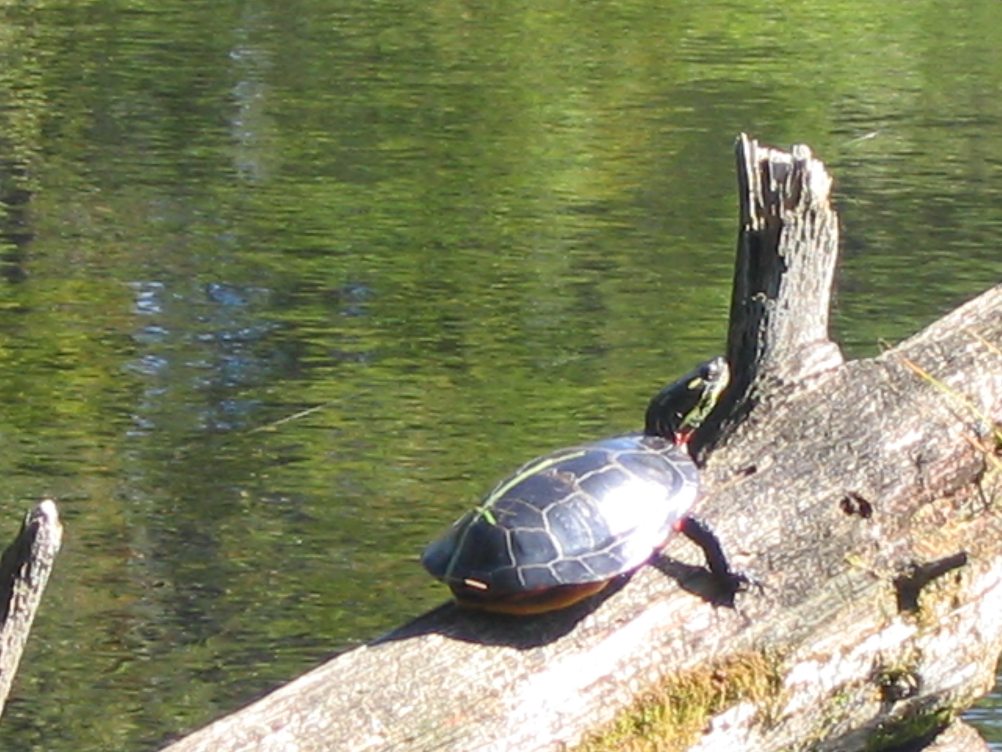
Turtle painted (2)

Painted Turtle

Taylor Pond Water Levels & Flooding Report

By Marc Tardif, 7/3/2013

Last year, the TPA newsletter included an article by Dana Little and Susan Trask summarizing some of the many considerations associated with water level control. The article was largely in response to inquiries the board received from the general membership concerning the extensive flooding we experienced in June of last year. To further address membership concerns, the board established a water level committee with the task of identifying the natural and manmade influences having the biggest impact on water levels and flooding. The ultimate goal of the committee is to determine if viable opportunities exist to reduce the extent and duration of flood events. The board does not endorse control of normal water levels on Taylor Pond, and the water level committee is not engaged with any activity in that regard.

Over the past year, the water level committee has been very active with field surveys and meetings with professionals knowledgeable in hydrology and local conditions. The committee would like to acknowledge and thank the following organizations for their contributions of time and expertise which has led to the preliminary conclusions contained in this report: Stony Brook Land Use Consultants; Jones Associates Land Surveyors; John Field Geology Services; Auburn City Engineers office, Auburn Water and Sewer District, and the Auburn Public Works Department. A substantial amount of information has been provided by these sources and will be made available to view on the TPA website.

Flooding is a function of the broad and complex subject of hydrology. There are three primary factors that affect the extent and duration of a flood event. 1) The amount and rate that water is introduced to the watershed. 2) Storage capacity of the watershed at the onset of precipitation. Before flooding occurs, features in the watershed that are capable of holding water need to fill and overflow. This includes depressions in the land, soil saturation, dams, and the pond itself. 3) The rate at which water is allowed to exit.

Taylor Brook is the primary outlet for water exiting the pond in both normal and flood water conditions. Six features of the brook have been identified from the pond outlet to the Kendall Dam 1.5 miles downstream that affect both conditions in and around Taylor Pond. The brook elevation drops dramatically immediately after the dam, so there is no impact on the speed of pond water level recession from conditions located further downstream.

The first feature effecting the time it takes for water levels to recede is the fact that there are only two feet of elevation drop over the 1.5 mile stretch. The very gradual slope provides minimal energy to move water downstream and away from the pond. Thick vegetation throughout the stream course further reduces flow rates and results in what can be described as a very sluggish waterway.

The second feature of interest can be found a few hundred feet downstream from the pond outlet. Here we find a heavily vegetative area rooted in silt deposits that have raised the bottom of the stream channel. This raised area is referred to as a berm and extends the full width of the brook. The bottom of the channel in the berm area is higher than any other point along the 1.5 mile course. The significance of this naturally created feature is that this is the point where water would stop flowing from the pond and into the brook under receding low water conditions. Water levels below this elevation would be the result of water exiting by ground infiltration, evaporation, and transpiration. The berm has little or no significance relative to flood water dynamics.

The third significant feature is located just downstream of the berm where two culverts are installed at the point that the brook passes under Hotel Rd. Unlike the berm, this feature has no effect on normal water levels. However, under flood water conditions, this feature acts as a dam of sorts that limits pond discharge to the maximum flow capacity of the culverts. Another negative characteristic associated with this feature under flood conditions is that large amounts of water accumulating from the downstream Taylor Brook watershed backs up against the culverts further reducing water discharge rates from the pond.

The fourth feature encountered traveling downstream from Hotel road is a large beaver dam located adjacent to the Granite Mills Estates development. The dam traverses the entire width of the brook, and water elevation drops one foot between the upper and lower sides of the dam. This feature doesn’t have much if any effect on normal water level since its elevation is slightly below the height of the berm. The dam does have some negative impact on mitigating a flood event in that the water volume retained by the dam is volume that is not available for storage of storm water accumulations.

The fifth feature of interest is the slab bridge located on the driveway to the Kendall property. This is probably the most significant manmade influence affecting the time it takes for flood water levels to recede. The bridge acts in the same manner as the Hotel Road culverts by restricting flow rates. The restricted flow at this point exaggerates the backed up water condition at the Hotel Road culverts. The only impact this feature might have on normal water levels in the pond would be the slight increase in the time it takes for water levels to recede.

The sixth and last feature to discuss is the Kendall Dam which is located just below the Kendall driveway bridge. The dam has a higher flow capacity than the bridge, and is equipped with a currently inoperable sluice gate which might be used to further increase flow in a flood event. Flow restriction over the dam is somewhat moot at this time since the upstream bridge is more restrictive than the dam. The dam has little or no effect on normal water levels in Taylor Pond since the elevation of the dam’s spillway is below the berm elevation. The Kendall dam has the same effect as the beaver dam under flood conditions in that the volume of water retained by the dam is volume not available for storage of storm water accumulations.

The information used to prepare this report is reliable and adequately detailed to support the conclusions expressed above. Given the heightened level of understanding we now have, several options to reduce the extent and duration of flood events have been suggested. The most promising options entail methods to increase the flow capacities of the Kendall Road Bridge and Hotel Road culverts. Unfortunately, the existing data we have is not adequate for the purpose of quantifying the extent that any one feature contributes to the overall problem of flooding. If undertaken, the next step in this process would involve an  expert analysis to determine benefits which would be realized by modifying existing features. The value of any proposed benefit would need to be weighed against the cost to implement modifications. To be viable, several state and local authorities having jurisdiction would need to be on board with the process. The concerns articulated by Susan and Dana in the 2012 newsletter remain pertinent and should be revisited before additional action is taken.

TPA Shoreline Improvement Grant Update

By Susan Trask, 6/23/2013

Are you thinking about making some improvements to you waterfront property? Would you like to make your space more beautiful and also help to secure the future health of Taylor Pond? Please consider applying for assistance from the Taylor Pond Association!

For the seventh straight year, the Taylor Pond Association is offering matching grants of up to $500 for watershed residents to improve their property in lake-friendly ways. “Lake-friendly” improvements include (but are not limited to) creating or expanding a buffer strip, installing rip-rap, creating better walkways to the water, etc. So far we have awarded five grants, expending $2500. The process is simple:

  1. Contact Susan Trask at 784-4606 or [email protected] and let her know that you are interested in making some improvements to your property. She will ask an expert from AVSWCD (Androscoggin Soil and Water Conservation District) to schedule a visit to your property to evaluate your situation and make recommendations.
  2. Carry out your project, following the guidelines given. Save all your invoices and records of personal hours expended.
  3. Contact Susan to let her know that the work has been completed. She will schedule a return visit by an AVSWCD expert who will evaluate the work and send a report to the Board.
  4. Send copies of all your expenses and personal hours expended to Susan.
  5. If the work completed follows best-practice guidelines, the Board will vote to award the grant, up to $500 in matching funds.

If you are even just thinking about what to do with your property, please consider getting some expert advice first! We will send someone out to consult with you. You have the benefit of professional expertise even if you ultimately decide not to apply for the grant.

By Susan Trask 6/23/2013

Geomorphology Report on Taylor Pond

John Field, PhD, 5/14/2013

Dear Mr. Dixon:

This letter shall serve as a report on the results of a qualitative geomorphic assessment I conducted for the Taylor Pond Association.  The goal of the assessment was to better understand the causes for siltation at the Taylor Pond outlet and to provide management recommendations for controlling flooding and erosion between the outlet and the Hotel Road crossing approximately 950 ft downstream.  This reconnaissance level effort consisted of a site visit on April 26, 2013 and a review of: 1) historical aerial photographs available through Google Earth; 2) historical topographic maps accessible online at http://docs.unh.edu/nhtopos/nhtopos.htm; and 3) previous letters, reports, and other documents related to the Taylor Pond outlet compiled by the Taylor Pond Association.  The findings of the assessment are described below.

The channel of Taylor Brook at the outlet of Taylor Pond is approximately 10 ft wide and flows along the southern side (or right side of the valley looking downstream) of the 125 ft wide valley (Figure 1).  Approximately, 450 ft downstream of the outlet the channel diverges into multiple poorly defined channels that spread across the entire valley.  The channels flow through a wetland complex before reconverging just upstream of Hotel Road into a well defined single 25 ft wide channel.  An historical topographic map from 1908 shows a single channel extending from the outlet to the Hotel Road crossing and beyond (Figure 2), but smaller channels that existed at the time may not have been shown.  Historical aerial photographs extending back to 1997 on Google Earth demonstrate multiple channel threads have been present for at least the past 15 years between the outlet and the Hotel Road crossing.

Local residents have expressed concern about flooding and erosion in the outlet area.  Previous letters and other documents regarding the outlet area demonstrate that these concerns have been expressed at various times over the past 30 years and likely longer.  A riprap revetment was constructed along the southern edge of the valley just downstream of the outlet to address bank erosion (Figure 3).  Other landowners have expressed concern regarding flooding and erosion along the northern edge of the floodplain downstream of where the brook diverges into multiple channels.  While bare sloughing banks, typical of severe erosion, are not evident at this location, recent sand deposition along the edge of the floodplain indicates at least minor flooding of neighboring lawns is possible.

Concerns about siltation in the channel, and its association with flooding and erosion, have been expressed since at least the 1980’s as demonstrated by documents compiled by the Taylor Pond Association.  Infilling of the channel would reduce the capacity of channel to convey flow and thus would increase the river stage for the same discharge.  The reduced channel capacity due to siltation would encourage the development of a wetland complex with numerous diverging channels as seen downstream of the outlet.  Siltation in the channel can also contribute to bank erosion as the diverging channels flow against the valley margins.  Homes and other buildings above the floodplain level are not likely to be significantly impacted by increases in flood stage due to siltation as flood stage would not rise rapidly, even with significant increases in discharge, given the wide floodplain present.  This is not to suggest a severe event would not be capable of causing severe flooding, but siltation in the channel is likely to have only a minor impact on conditions beyond the floodplain margins.  Severe erosion beyond the floodplain margins is also unlikely as the diverging channels are unlikely to expand beyond the current width of the valley.  Furthermore, the erosive power of the brook is diminished when the flow is split in multiple channels.  The potential for erosion would be greatest if and where the flow is contained within a single channel and access to the adjacent floodplain is blocked.

Human alterations along Taylor Pond and Taylor Brook have also potentially increased flooding in the outlet area.  A comparison of the 2012 aerial photograph (Figure 4) and 1908 topographic map (Figure 2) illustrates how the construction of homes and associated berms in the 1970’s has blocked off a former wetland along the southern margins of the pond.  Previously, the wetland area would have provided flood storage during periods of high flow, but now that flow more quickly reaches the outlet.  Other development throughout the watershed has also been discussed in previous documents as a potential cause for increased flooding since previously forested areas have been converted into homes, roads, and other impervious surfaces that lead to greater runoff.  The presence of the Stevens Mill Dam and the Hotel Road culvert may lead to flow impoundment and higher flood stages in the outlet area.  Hydrologic and hydraulic modeling would be needed to determine how significantly these various factors alter flood stage for various rainfall events and discharges, but the impact of increased runoff due to development in the watershed is likely minimal given the still small percentage of development in the 14.9 mi2 watershed.

Efforts to manage siltation at the Taylor Pond outlet have likely been ongoing since the early 20th century.  The 1908 historical topographic map shows the Taylor Brook channel between the outlet and Hotel Road in a nearly straight alignment flowing along the southern edge of the valley.  Although other side channels may have been present at this time, as described above, the straight alignment along the valley margins are indicative of an artificially straightened channel.  The straightening was likely undertaken to increase flow velocity and thereby reduce flooding and siltation of the channel.  However, by containing flow in a single channel, the erosive force of the stream would be increased and may be contributing to present-day erosion problems being managed at the outlet (Figure 3).

Documents compiled by the Taylor Pond Association allude to proposals in the 1980’s to dredge the channel, indicating that efforts to manage siltation at the outlet continued throughout much of the 20th century.  The need for dredging in the 1980’s as expressed in the compiled documents also indicates that channel straightening and removal of silt are not sustainable management approaches.  The Stevens Mill Dam and the narrowing of the channel at the Hotel Road crossing have been identified as potential causes for siltation and increased flooding as described above.  While detailed surveying and hydraulic modeling would be needed to determine how these structures impact flow, the natural setting is also an important factor promoting siltation in the channel.  The channel is relatively narrow compared to the valley through which it flows and can be characterized as an underfit stream.  Underfit streams are streams that flow through a large valley that was carved by much larger discharges that no longer occur under the current hydrologic regime.  In the case of Taylor Brook, the larger discharges forming the valley were likely associated with glacial meltwaters at the end of the last ice age.  Given the low slope and wide valley carved by these higher discharges, the current stream is unable to effectively transport sediment through the reach, leading to a sluggish meandering channel or a multi-thread channel flowing through a wetland.  As such, channel straightening, dredging, and other management efforts that attempt to increase the stream’s capacity to transport sediment are ultimately unable to overcome the natural tendency for siltation in the area, a condition that is likely to persist into the future.

Future management of Taylor Brook in the outlet area must be conducted with this understanding of a natural tendency towards siltation.  Great expense could be incurred removing the Stevens Mill Dam and enlargening the Hotel Road crossing with little increase in flow velocity or reduction in siltation.  If the channel is to be dredged, straightened, and confined to a single channel, such efforts must be undertaken with the realization that such management efforts will need to be periodically repeated as the channel once again fills with silt and multiple channel threads develop.  Since the erosion resulting from siltation in the channel is unlikely to severely impact homes and other infrastructure immediately adjacent to the floodplain margins, vegetative solutions are the most sustainable management approach for the erosion problems.  Plantings along the banks of those channels that flow along the margins of the floodplain will serve to absorb the channel’s erosive energy without unduly transferring erosive forces downstream as can occur when using rock riprap.

Please let me know if you have any additional questions related to the assessment reported above or regarding the recommendations made.  In general, I do not see siltation in the channel as resulting in significant flooding and erosion to properties near the outlet area.

Sincerely,

John Field, PhD

Invasive Plants:

By Dana Little, 6/21/2012

The earliest findings of plant use by people are flowers placed in a Neanderthal  grave site found in Iraq dated 25,000 years ago.  Crop agriculture in the Fertile Crescent area of the eastern Mediterranean dates back to 10,500 years ago.  The Chinese cultivated rice 8,000 years ago along the Yangtze River.  Early farmers in Mesoamerica, Andean South America and eastern North America all independently developed agriculture.  Our backyard gardens today contain representatives from all over the world: potatoes from Peru, broccoli from the northern Mediterranean region, corn from Mesoamerica, beans of various types from Afghanistan, Egypt, Peru and North America and various kinds of squash from Mesoamerica.

When people find a plant that especially attracts them for its food or aesthetic value they transport it long distances.  Where would we be without the spicy peppers that came from Mexico found in Szechuan cooking or the tomatoes that hail from Peru and characterize Italian cuisine?  Our gardens would be impoverished without the roses first cultivated 5,000 years ago in China and poppies grown 4,500 years ago in Southern Europe and North Africa.

However, some plants can become a nightmare when transported to new locations.  We call such plants invasive.  Invasive plants may cause problems by crowding out a more desirable native species, shading slower growing plants or reproducing faster than native plants.  The Japanese brought Kudzu, also called the “Mile-a-minute Vine”, to the bicentennial celebration in the US in 1876.  In Japan they ate the starchy roots and livestock grazed on the green leaves.  In the US, people loved the purple flowers and the shade provided by the rapidly growing vine.  In the 1930s the government planted millions of seedlings in the South to control the erosion that tobacco and cotton farming created.  Without natural predators, it grew up to 60 feet yearly, smothered native vegetation and climbed over anything in its way, including trees and homes.  By the 1970’s the US declared Kudzu a weed and today economists calculate it costs the forestry industry 100 million dollars a year.

Beekeepers and plant lovers first transported another invasive plant, Purple Loosestrife, to the US in the 1800’s.  The plant produces three million seeds every year which are rapidly carried by wind and water to settle in any moist soil.  Now large tracts of wetland have few plants other than Purple.  Scientists fortunately have discovered that the introduction of a number of insect pests can control it.

Invasive Purple Loosestrife

Purple Loosestrife

Another invasive, a species of grass, Phragmites australis, comes from Europe where grazing cattle kept it under control.  In the US Phragmites grows anywhere from 6-18 feet tall and spreads at a rate of 30 feet per year, quickly shading out the native cattails and other wetland species.  Bird and mammal diversity drops rapidly when this grass takes over.  We see monoculture Phragmites swamps for many miles along 495 driving down to Boston.  We have a small colony starting on the southwest cove near my home.

Pond edge

Phragmites on the east side of the pond intermixed with Button Bush and Cattails.

You can find lists of invasive plants at www.invasive.org or www.eddmaps.org .  Plants commonly sold in nurseries are listed on these sites and include Barberry, Oriental Bittersweet, Norway Maple, Honeysuckle, Russian Olive, English Ivy and Winged Euonymus.  There are nearly 1200 plants native to New England.  Buying native plants ensures that you will not spread invasive plants.  If you educate yourself before transplanting new plants you will keep our pond healthy.

Snail Invasion

by Dana Little 4/27/2012

Large snails known as Chinese Mystery Snails have invaded Taylor Pond.  Found normally in Southeast Asia, Japan and eastern Russia, people first brought these snails to San Francisco in 1892 for the Asian food market.  They released the snails into local streams to provide a supply of these edible snails.  They quickly spread and were found in Boston as early as 1915.  They have been reported in at least 35 other towns in the state but not previously in Taylor Pond.    They spread easily and have been found attached to boats and inside bait buckets.  People in the aquarium trade use the snail for cleaning algae off glass and sometimes release them into ponds.

Invasive Mystery Snails

Two Mystery Snails with a smaller native species.

This snail thrives at temperatures from 34-80 degrees, just the range we typically see in Taylor Pond.  They tend to live in shallow water plowing shallow grooves as they burrow just below the surface of the mud.  They migrate to deeper water to winter over.  They are about the size of a large walnut and have a brownish greenish shell.  When stressed they have a trapdoor (operculum) that they shut and can survive extreme heat, cold and most pesticides intended to kill them.  They feed on algae and microorganisms found in the mud.  Their toughness and willingness to eat rotting organic matter has yielded a large population in Taylor Pond.  Fortunately crows and diving ducks enjoy eating them.  On Sabattus Pond I have often observed ducks (Lesser Scaup) swallowing these snails in one large gulp.

A single female snail can produce over a hundred babies, each of which can live up to 5 years.  When they die they may wash up on shore where they produce a foul odor.  According to the US Geological Service website this species “has exerted no recorded impacts in the Great Lakes and is considered relatively benign.”  So rest easy and enjoy some escargots fried with garlic and wine sauce.

Water Levels on Taylor Pond

By Susan Trask and Dana Little, June 21, 2012

Those of us who live around Taylor Pond will remember the first weekend of June, 2012 for a long time. We discovered that we live in a flood plain.  Although heavy rains were predicted, none of us expected nearly nine inches in three days! Those of us who live on the north end experienced submerged docks, floating furniture and runaway boats. Those at the south end fared much worse, with houses surrounded by water, sump pumps useless, and sewage backing up through showers. The lake was quick to fill (it rose an estimated three feet in those three days), and, at this writing 10 days later, is just now receding to what we consider “normal” levels.

The prolonged flooding at the south end of the Pond provoked much conversation among waterfront property owners this year. Recurring speculation about a dam or dams preventing outflow resurfaced, and inquiries were made to the TPA Board about the flooding problem. Here’s a summary of the concerns expressed along with a little history and a bit of research.

Flood

Canoes come out to get down the driveway during the flooding of April, 2005.

First, it should be noted that all of the properties located at the south end of Taylor Pond are within the 100-year flood plain. A look at FEMA’s recently updated flood plain map shows that Pondview Dr., Ledgeview Dr., Valview Dr., Chicoine Ave., and much of Garfield Rd. are within this area. The floodplain map may be viewed via the City of Auburn website. Although the recent 3-day storm was not of the “100-year” magnitude, it was the most significant (in terms of rainfall and water level) in about 25 years.

Many people have considered the outlet to be the source of high water.  There have been reports of beaver dams and brush swept downriver that might clog up the drainage of water from the lake.  In addition there has been concern that the dam located on Taylor Brook might impact the water level.  When the state wildlife officials investigated several years ago they found no obstructing beaver dams, that Taylor Brook empties the pond unimpeded and that the dam on Taylor Brook does not affect the water level in Taylor Pond.

Anyone who has tried to navigate through the outlet has found that it’s extremely overgrown and congested. In 1974 a group from the Taylor Pond Association mounted a clean-up effort there, which resulted in the removal of huge amounts of trash and debris. Although the area was undoubtedly improved by the action, residents found very little difference in the water level. People have proposed dredging the outlet to lower the pond’s water level or requesting a lower level on the Taylor Brook dam downstream.

According to Jim Glasgow of the Maine DEP, any alteration in Taylor Pond’s water level from dredging, installation of a new dam or alteration of the Taylor Brook dam would require a permit.  A consensus of homeowners on the Pond would have to agree to and pay for the permit process and project.  At a minimum a project like this would take the services of an engineer to design the method, a biologist to assess the environmental impact and a construction firm to carry out the process.

Sabbatus Pond provides an example of the regulatory process.  In 1978 the DEP first started the assessment process issuing their order after 11 years of deliberation.  In order to develop a consensus many public meetings occurred in which they considered spawning grounds, alewife stocking, migration of eels, replenishment of water in marshes, recreational fishing, duck hunting, access to boat ramps, swimming, dock installations, flooding from water releases, prevention of damage from ice formation, algal blooms and finally the interests of homeowners in preventing flooding.  Once the DEP evaluated all of these issues they came up with an order that established lake levels that varied with the season.  Failure to adhere to the order at any time in the future would result in the dam being fixed at a set level potentially leaving Sabattus Pond even more vulnerable than Taylor Pond to flooding.

Installing a dam can actually worsen flooding.  Engineers design dams to manage up to a certain water level.  Above that water level, dams restrict the exit of water which increases flooding during a torrential downpour.  For example, on Patriot’s day in 1997 Panther Pond flooded following a heavy rain because the dam restricted outflow.  It took two weeks after the storm for the water levels to return to normal.  The Dead River dam provides another example of what occurred during the June 2012 rainstorm.  Mark Margerum, at the Maine DEP, reports that the dam increased flooding around Androscoggin Lake by restricting water outflow.  According to Jim Glasgow also at DEP, the dam into the Presumpscot River limited the outflow of water from Lake Sebago causing many properties to flood during the same June downpour that affected us.

Unfortunately with heavy rainfall many properties in the flood zone will continue to flood.  Taylor Pond Association does not regulate the level of the pond.  Streams, springs and rainfall all raise the pond level.  Water exits the pond by Taylor Brook and evaporation. Artificially altering lake levels requires a costly, complex and lengthy consensus process that considers many factors besides flooding.  Dredging, cleaning the outlet, building a dam or altering existing dam levels will not prevent flooding from an unusually heavy rainstorm.  We wish there were an easy answer but there is no simple solution to protect homes in a flood zone.

Ducks: To Feed or Not to Feed

Dana Little, June 1, 2010

The law protects any migratory birds from harassment or injury but does not prevent you from feeding them.  According to Judy Camuso of Inland Fisheries and Wildlife, feeding ducks and geese on Taylor Pond is not against the law, but it’s not a good idea, for several reasons.

Attracting large numbers of ducks and geese into a small area produces a huge amount of concentrated excrement.  One goose produces about 1/3 pound of feces per day and a duck, about half that.  This winter I counted over 200 ducks being fed by one person.  This produced 2 tons of fresh manure, yielding over 11 pounds of phosphorous, potentially affecting water quality.

A couple of mallards on the dock.

A pair of Mallards hang out on the dock.

“Swimmer’s itch” comes from a parasite called Schistosomiasis released into the water through duck feces.  The more ducks concentrate in an area, the more likely the disease will affect swimmers.  When eggs in duck waste hatch, the small larvae (miracidia) then infect snails.  The larvae mature into cercariae which leave the snail to infect another duck.  Immature parasites can burrow into the skin of human swimmers and waders, causing an itching rash for up to one week.  Ducks also carry Salmonella, a bacteria, that can infect both people and animals and cause bloody diarrhea.

Over the years I have spotted 14 different species of ducks on the Pond.  Many use it as a staging point on their migration to and from water in northern Maine and Canada.  We have at least six species known to breed on Taylor Pond in the summer: Wood, Mallard, and Black Ducks, Hooded and Common Mergansers, and Canada Geese.

I do not recommend feeding the ducks.  If you do feed them, understand that an artificial diet may cause Duck Virus Enteritis that can kill off the entire population.  The only artificial diet should be high quality grains that are free of mold or spoilage.  However, ducks routinely fed on such a diet tend to become obese, develop heart disease, liver problems and malnutrition.  Uneaten food should be quickly removed because left over food will attract rodents and can quickly grow a fungus, Aspergillus, that is fatal to ducks.  Rotting food may contain botulism that quickly kills ducks.

An overfed duck will not be able to fly as fast or escape from predators.  In addition, when food is provided in the winter they may not migrate to a climate more suitable for them.  The best nutrition for a duck consists of natural foods growing in their environment that allow them to be trim, fly fast and stay healthy.

If you must feed the ducks, provide food only intermittently and in small amounts to avoid large collections of birds.  Finally, I hope that you will, most of all, appreciate the wild nature of the ducks, keeping them at a distance.

Ice-out: Fun, Facts, and Reality

by Susan Trask, 6/13/2010

The first sign is usually a darkening of the thick dirty gray surface. Then you start to notice some small openings along the shoreline, and perhaps some wet-looking patches scattered here and there. Sometimes it will freeze back solid, but you know that the end of the long, still winter of ice on the lake is not far away.

Winter ice

Ice out April 9th, 2004.  This patch of ice blew into a cove on April 14th that year.

It’s never the same twice. Some years, you will awake to a suddenly-open expanse of water stretching nearly all the way across. Once you have large open patches, a good wind on a sunny day can do away with most of the ice in short order. Other years that darkening effect continues, until the ice gradually disappears. (No, it doesn’t actually sink, although many will insist that it does.) My favorite years are those where the deteriorating ice becomes honey-combed, with long shards that tinkle together when the wind blows like eerie, magical wind chimes.

It seems that each lake or pond has its own tradition of how one actually defines “ice-out.” In an earlier less eco-conscious time, some folks would drive a car out onto a certain spot on the lake and record when it fell through. Many lake watchers define ice-out it less dramatically, say by when one can navigate from Point A to Point B, or merely when the ice is “virtually gone” as the Auburn Water District does. On Taylor Pond, a number of lakeside enthusiasts kept an ice-out pool for many years, whose winner was determined when Jan Marston and Pat Garcia certified that they couldn’t see any ice in any cove. However the various locations define it, nearly everyone in the state noted their earliest-ever ice-out in 2010. This year Taylor Pond beat its previous record, set in 1981, by eight days, clocking out on March 20.

Those of us lucky enough to witness the ice-out phenomenon yearly count it as a real turning point, a sure sign that spring is coming soon, that muddy yards will be dry enough to pick up winter’s debris, that we can begin to look for crocuses peeking through the remaining snow. The earlier the better, right? The docks and boats in sooner, more days of boating, fishing and swimming. What’s not to like?

Here’s where a few facts of lake biology come in. Once the ice is gone, the sun warms the surface of the water and provides nutrients for algae and other plants to begin growing. The lower part of the lake remains relatively cold. Obviously, the more sunny days we have, that upper warmed layer will be larger and the bottom colder layer will be smaller. Since the biological activity of the growing plants depletes oxygen, less of it will be available in the colder layers for fish. According to director of VLMP (Volunteer Lake Monitoring Program) Scott Williams, that warmer upper layer also creates a “more biologically productive environment for algae growth” and the possibility of increased proliferation of invasive plants. (So far, we don’t have any of these on Taylor Pond!)

Some will be quick to conclude that the state-wide recording breaking of ice-out dates is because of global warming. Others will point out that one cannot pin down the data of a single year to a single cause. Whatever the cause, we can certainly enjoy the benefits of our early spring. While we do, however, let’s also recommit to doing all we can to prevent our own actions from further jeopardizing our beautiful resource. Remember, the simple things really count: Keep a good buffer strip, refrain from using phosphorous-laden fertilizers, and control your boat wakes. As we take full advantage of this beautiful season this year, let’s also be sure we do all we can to enjoy many spectacular ice-outs in the future!


For the record: Here are Taylor Pond’s ice-out dates back through 1969, courtesy of Peg Wallingford and Jan Marston:

1969 Apr 21 1980 Apr 11 1991 Apr 8 2002 Apr 8
1970 Apr 27 1981 Mar 26 1992 Apr 15 2003 Apr 13
1971 May 1 1982 Apr 25 1993 Apr 21 2004 Apr 9
1972 Apr 30 1983 Apr 5 1994 Apr 19 2005 Apr 12
1973 Apr 17 1984 Apr 18 1995 Apr 13 2006 Apr 2
1974 Mar 16 1985 Apr 14 1996 Apr ? 2007 Apr 12
1975 Apr 25 1986 Apr 12 1997 Apr 23 2008 Apr 21
1976 Apr 14 1987 Apr 11 1998 Apr 8 2009 Apr 12
1977 Apr 14 1988 Apr 10

Turf Grass Experts’ Top 10 on Lawn care

By Dana Little, June 6, 2010

What could be more beautiful than a healthy green lawn?  Let me suggest some alternatives:  a garden of flowers, a collection of attractive bushes and a buffer strip of untouched land next to the lake for the wildlife.  Why do we worry about lawns running right up to the lake?  Because lawns are the major source of phosphorous run-off into the lake.  In a buffer strip the rain water slowly percolates through the soil which naturally cleanses it of phosphorus.  A lawn maintained right up to the pond’s edge allows rain to wash phosphorous off the surface of the soil directly into the pond.   Fertilizers applied to the lawn provide another source of phosphorous run-off.   Phosphorous in fertilizers is seldom needed and yet, is widely used.  Maine Law now makes it illegal to sell phosphorous- containing fertilizers without notifying customers of the issue.  Fertilizers with no phosphorous can be bought in all local stores and will not harm the lake.

So, if you must have a lawn, here are the experts’ top 10 recommendations:

  1. Fertilize only if necessary, once or twice, best in late August or September and then only on new or young lawns less than 10 years old.  Only one-quarter to half the usual recommended amount is necessary.  Pesticides and herbicides can run off into the pond hurting fish and water quality.  Fertilizers that contain pesticides and herbicides increase the problem that can occur with “fertilizing” the lawn.
  2. Perform a soil test to determine which nutrients are needed.  Seldom in Maine do you need phosphorous or potassium.  Nitrogen is the only common nutrient needed and then not on lawns over 10 years of age.  Mulching the lawn clippings on the lawn and mixing clover into your lawn seed provide all the nitrogen most lawns need.
  3. Mow high, at least 3 inches, for vigorous roots and to shade out weeds
  4. Use a mulching mower that will leave the grass clippings on the lawn for a high-quality, phosphorous-free fertilizer
  5. Plant the right species of grass.  Avoid Kentucky Bluegrass which requires high levels of fertilizer and water and use turf-type tall and fine-leaf fescues.  Grass seed mixtures ideally should include herbs such as chamomile, yarrow and clover.  These “weeds”, often killed off with pesticide applications, take nitrogen from the atmosphere and make it available to the grass.
  6. Keep the grass dense.  Higher density means fewer weeds.  At the first sign of thinning, loosen the soil with a rake and apply an appropriate grass mixture.
  7. On older lawns that have been heavily fertilized thatch can build up.  If the thatch is thicker than ¾ inch it can be reduced by a core aerator that punches holes in the ground or by applying  1/8 inch of compost over the entire lawn which will cause the thatch to decompose.
  8. Water your lawn only if it has rained less than an inch in the last week.  Watering daily encourages shallow roots and an unhealthy lawn.  Water once a week to provide for one inch over the entire lawn using a rain gauge to measure your sprinkler’s output.
  9. Keep fertilizers and clippings off sidewalks and driveways where rain can wash them into the pond.
  10. Keep mower blades sharp to prevent tearing of the grass which promotes disease.